
On The Extensive Employment of Cotton in the form of a Native Manufacture, as a convenient currency —
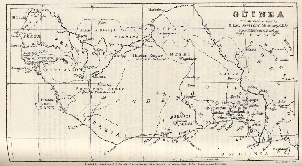
And on the Repatriation of the Negro, to promote, on any Definite and Established Basis, the Development of His Own Country. — (See Map)
By His Excellency Governor Moloney, C.M.G., of Lagos.
[Addressed to the Members in the Mayor’s Parlour, on Friday, November 15th, 1889, at three p.m., His Worship the Mayor of Manchester in the chair.]
..On the occasion of his visit in 1822-24 to Sockatu (Sockatoo), Captain Clapperton was favoured by Sultan Mohammed Bello, of Houssa, with a geographical and historical account of Takroor (vide Appendix xii. to ” Discoveries in Africa,” by Major Denham, Clapperton, &c), in which we find mention of Yarba (Yarriba or Yoruba) as an extensive and interesting province flanked by the sea, and having an anchorage for ships of the Christians who visited the coast to purchase slaves obtained in Central Africa, notably Houssas, who were sold to the Yarbas, and by them resold to the Christians.
We also find in the same work a map of Central Africa , which shows the middle Niger, and fairly accurately the positions of Boussra (Boussah or Boussang) and of Yarba, with the direction of its trade route to the seaboard, which agrees with one that at present exists viâ Iseyin, Abeokouta, and Badagry – famous as the starting-point across Yoruba to Boussah of Clapperton and the Landers.
On the authority of Bello, the inhabitants of Yarba descended from the children of Canaan, who were of the tribe of Nimrod. They were driven into East Africa out of Arabia by Yaa-rooba, son of Kahtan, and they subsequently migrated westward and established themselves at Yarba.Again , the name Yoruba is associated with Quorra (goru, river, in Fulah, and the affix ba great ), viz., the people of the great river.
Among themselves, Yoruba is given as the name of a former King of one of its provinces, who succeeded to rule over all to which he gave his name. Yorubaland may be said to be now composed of the area situate south of the 9º of N. latitude , between the Ewe territory (Whemi or Dahomey) and the Niger main stream.
The territorial wedge situate between the Volta and Niger rivers is divided between the Ewe and Yoruba speaking peoples, the former occupying the western and the latter the eastern portion, contiguity being represented by the longitudinal line through the mouth of the Ajera or Giddy river, continued to the territory of the kingdom of Borghu.
The population of Yoruba is given as 3,000,000, its area as 25,000 to 30,000 square miles, and it may be compared in size to Belgium and Holland. Over it we have for years directed from Lagos our influence. Our relations with it have now been placed beyond dispute or foreign interference by treaties and otherwise. Such connection has been assured and confirmed by international understanding officially recognised.
The colony of Lagos, which is the seaboard of Yoruba, was acquired by treaties in August, 1861, and July, 1863. These treaties conveyed to Her Majesty the whole territories of the cedents. Later additions were made at the wish of the native authorities concerned as follows : kingdom of Katanu in 1879, of Appa in 1883, and of Mahin, Jakri, and of Sobo in 1885.
- Guinea to illustrate a Paper by H. Exc. Governor Moloney, C.M.G. – https://digital.library.illinois.edu/items/4d5ca6a0-e946-0133-1d3d-0050569601ca-f

Leave a comment